ছবি:Map Norway political-geo.png

এই প্রাকদর্শনের আকার: ৩৯৬ × ৫৯৯ পিক্সেল। অন্যান্য আকারসমূহ: ১৫৯ × ২৪০ পিক্সেল | ৩১৭ × ৪৮০ পিক্সেল | ৫০৮ × ৭৬৮ পিক্সেল | ৬৭৭ × ১,০২৪ পিক্সেল | ১,৯২০ × ২,৯০২ পিক্সেল।
আয়ৌপা ফাইলগ (১,৯২০ × ২,৯০২ পিক্সেল, ফাইলর সাইজহান: ৯২৪ কিলোবাইট, এমআইএমই-র অংতা: image/png)
সারাংশ
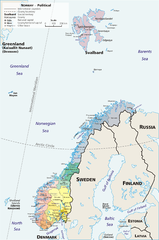
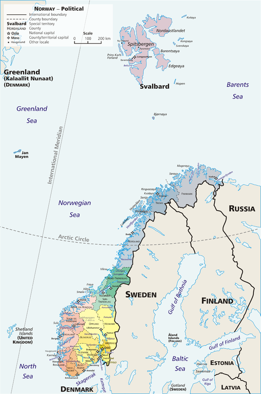
Map: Norway – geopolitical
Exhibits counties (fylker) of Norway (19); colours correspond to regions of Norway:
- yellow: Østlandet (Austlandet)
- orange: Sørlandet
- red: Vestlandet
- green: Trøndelag
- blue: Nord-Norge
Also:
Drawn by E Pluribus Anthony, adapted from:
- Statistics Norway: This is Norway Yearbook, p. 44 (PDF)
- National Geographic Xpeditions Atlas (Map Machine): Norway (PDF)
- Image:Bjornoya map.png

|
This map image could be re-created using vector graphics as an SVG file. This has several advantages; see Commons:Media for cleanup for more information. If an SVG form of this image is available, please upload it and afterwards replace this template with
{{vector version available|new image name}}.
It is recommended to name the SVG file “Map Norway political-geo.svg”—then the template Vector version available (or Vva) does not need the new image name parameter. |
লাইসেন্সহান
| এই কাজের প্রণেতা E Pluribus Anthony কাজটি পাবলিক ডোমেইনে প্রকাশ করেছেন। এটি বিশ্বব্যাপী প্রযোজ্য হবে। কিছু দেশে এটি আইনত সিদ্ধ নাও হতে পারে, যদি তাই হয়: |
Link: http://en.wikipedia.org/wiki/Image:Map_Norway_political-geo.png
derivative works
এই ফাইলের উপজাত কর্মসমূহ: Jan Mayen ringed.png
ফাইলর ইতিহাস
দিন/সময়-র গজে যাতিলে ঔ খেন্তাম পেয়া হঙিসে ফাইলগ চ পারতেই।
| দিন/সময় | হুরকাকরে ফটকগি | চাঙহান | আতাকুরা | মতহান | |
|---|---|---|---|---|---|
| এপাগা | ০৬:৩৬, ৩০ জুলাই ২০১০ | | ১,৯২০ × ২,৯০২ (৯২৪ কিলোবাইট) | Hayden120 | Restored map proportions to original. |
| ০৬:২৬, ৩০ জুলাই ২০১০ |  | ১,৯২০ × ২,৯০২ (১.০৪ মেগাবাইট) | Hayden120 | Corrected spelling of Trøndelag. | |
| ১৪:২৫, ১ মে ২০০৬ |  | ১,৯২০ × ২,৯০২ (৯৬৯ কিলোবাইট) | Mortadelo2005 | == Summary == Map: Norway – geopolitical Exhibits counties (''fylker'') of Norway (19); colours correspond to regions of Norway: * yellow: Østlandet (Austlandet) * orange: Sørlandet * red: Vestlandet * g |
জুরিসিতা
এরে ফাইলর লগে পাতার মিলাপ আসে:
ফাইলের বৈশ্বিক ব্যবহার
নিচের অন্যান্য উইকিগুলো এই ফাইলটি ব্যবহার করে:
- af.wikipedia.org-র ব্যবহারহান
- ang.wikipedia.org-র ব্যবহারহান
- ar.wikipedia.org-র ব্যবহারহান
- ast.wikipedia.org-র ব্যবহারহান
- awa.wikipedia.org-র ব্যবহারহান
- azb.wikipedia.org-র ব্যবহারহান
- az.wikipedia.org-র ব্যবহারহান
- ban.wikipedia.org-র ব্যবহারহান
- be.wikipedia.org-র ব্যবহারহান
- bug.wikipedia.org-র ব্যবহারহান
- ca.wikipedia.org-র ব্যবহারহান
- crh.wikipedia.org-র ব্যবহারহান
- cy.wikipedia.org-র ব্যবহারহান
- da.wikipedia.org-র ব্যবহারহান
- de.wikipedia.org-র ব্যবহারহান
- diq.wikipedia.org-র ব্যবহারহান
- dsb.wikipedia.org-র ব্যবহারহান
- dty.wikipedia.org-র ব্যবহারহান
- el.wikipedia.org-র ব্যবহারহান
- en.wikipedia.org-র ব্যবহারহান
- es.wikipedia.org-র ব্যবহারহান
- es.wikibooks.org-র ব্যবহারহান
- fa.wikipedia.org-র ব্যবহারহান
- fj.wikipedia.org-র ব্যবহারহান
- fo.wikipedia.org-র ব্যবহারহান
- fr.wikipedia.org-র ব্যবহারহান
এই ফাইলের অন্যান্য বৈশ্বিক ব্যবহার দেখুন।